Outstanding Geologic Features in Pennsylvania State Parks and Forests
A fascinating geologic story lies behind the spectacular scenery of Pennsylvania’s state parks and forests, yet you do not need to be a geologist to appreciate and enjoy these scenic geological features, which include:
- Vistas
- Waterfalls
- Rock cities
- Boulder fields
- Cliffs
- Gorges
- Islands
- Landforms
- Glacial features
Pennsylvania’s natural areas in state parks and forests are awe-inspiring, and the geologic stories about them have been pieced together to provide you with a glimpse of a remarkable, ancient past.
Trail of Geology Series
DCNR’s Bureau of Geological Survey created a series of publications of a sight-seeing nature for the geologic explorer in all of us.
The Trail of Geology publications consist of nontechnical booklets and papers describing the geology of selected Pennsylvania parks, trails (land and water), and points of interest.
If a Trail of Geology publication exists for a state park or forest, you can find a link to the publication on the individual state park or forest pages.
Must-See Geological Features in Pennsylvania State Parks and Forests
Archbald Pothole
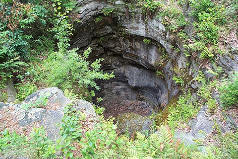
In 1884, anthracite coal miners discovered then excavated the large cobble-filled hole. The hole is 38 feet deep and elliptical in shape. The largest part is 42 feet long and 24 feet wide.
The natural pothole had cut through sandstone, shale, and coal of the Llewellyn Formation (Pennsylvanian age). Potholes are fairly common, circular holes found in bedrock in the streams of Pennsylvania and typically are a few feet deep at the most.
The extremely large Archbald Pothole is likely a relict of glacial times, probably forming as the Laurentide Ice Sheet began its retreat from northeastern Pennsylvania about 20,000 years ago.
How To Get There: Archbald Pothole is located northeast of Scranton at Archbald Pothole State Park.
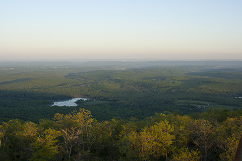
Big Pocono Overlook
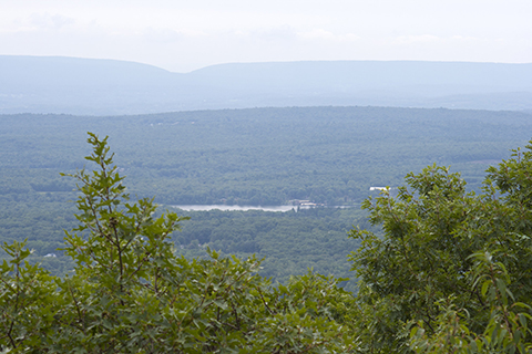
Big Pocono Overlook, also known as Pocono Knob, is situated on the east-west ridgeline of Camelback Mountain (2,133-foot maximum elevation). It is the highest location in the area and is located on the edge of the Glaciated Pocono Plateau.
The Delaware Water Gap through Kittatinny Mountain is easily seen to the east, along with more of the Ridge and Valley physiographic province.
On a clear day, the Catskill Mountains of New York can be seen.
How To Get There: Indian Trail offers a great vista from the eastern cliffs, visible from I-80 and points in Tannersville and Scotrun. Visitors may also connect to South Trail midway across the south face section from Parking Lot 3 using Vista Trail for a shorter loop.
Boulder Field
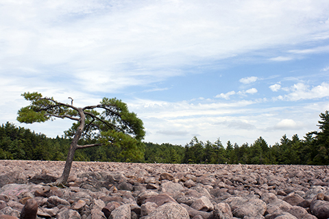
Hickory Run Boulder Field is one of the most remarkable geologic features in the state. It is located in Hickory Run State Park in northern Carbon County. The area is situated in the Glaciated Pocono Plateau section of the Appalachian Plateaus physiographic province.
The boulder field measures approximately 400 feet by 1,800 feet (about 15 football fields in area) and is at least 12 feet deep. This feature has remained relatively unchanged for thousands of years since glacial times.
How To Get There: From I-80, take Exit 274 at the Hickory Run State Park Exit, and drive east on PA 534 for six miles.
Hyner View
The rugged landscape seen from Hyner View State Park in Clinton County, Pennsylvania is characteristic of the Deep Valleys section of the Appalachian Plateaus physiographic province.
The section is composed of deep, narrow, steepsloped valleys that are separated by narrow to broad uplands.
How To Get There: From PA 44, turn west on Hyner Mountain Road and travel about five miles, just past the entrance to Hyner Run State Park. Turn left onto Hyner View Road. It is a five-mile drive to the view.
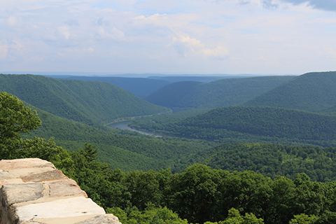
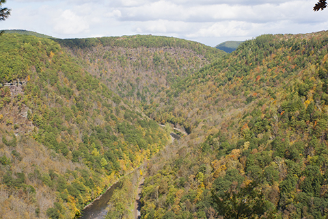
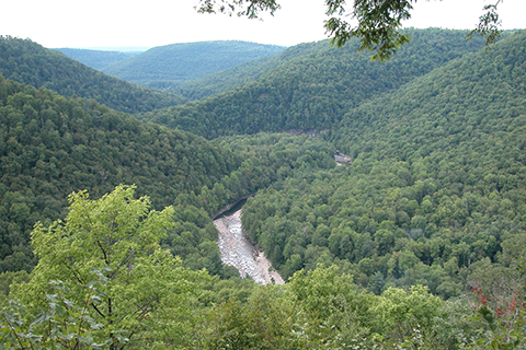
Lehigh Gorge
The scenic and rocky Lehigh Gorge winds through about 30 miles of the Anthracite Upland section of the Ridge and Valley physiographic province.
The gorge can be traced from below the Francis E. Walter Dam to the cut through Bear Mountain, just downstream of Jim Thorpe, Pa.
The Lehigh River drops over 740 feet in elevation as it flows down the gorge. Approximately 2,825 feet of folded rocks in the gorge are exposed, representing a 60-million-year interval from the Late Devonian through the Late Mississippian (383 to 323 million years ago).
How To Get There: Located a long Lehigh Gorge Trail
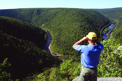
Pine Creek Gorge (PA Grand Canyon)
Pine Creek Gorge—also known as the Pennsylvania Grand Canyon—winds with Pine Creek for more than 45 miles from Ansonia to the north past Waterville to the south.
The gorge area is in the Deep Valleys section of the Appalachian Plateaus physiographic province. Views of the gorge are spectacular, showing wooded slopes on deep angular valleys.
Colton Point and Leonard Harrison State Parks are located at the northern end of the gorge and include numerous scenic overlooks, such as Harrison Lookout and Colton Point.
Here, the depth is more than 800 feet, and the distance from rim to rim is approximately 4,000 feet.
How To Get There: Colton Point: Take Rim Trail, a one mile easy hike that follows the perimeter of the “point” and links all over the overlook view areas together in a mostly flat hike.
Harrison Lookout: Take Overlook Trail, a 0.6 mile more difficult hike that passes Otter View to give you a view of the vista looking south.
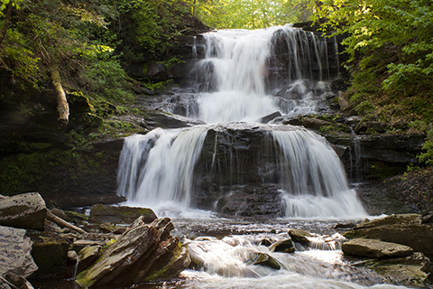
Ohiopyle Falls
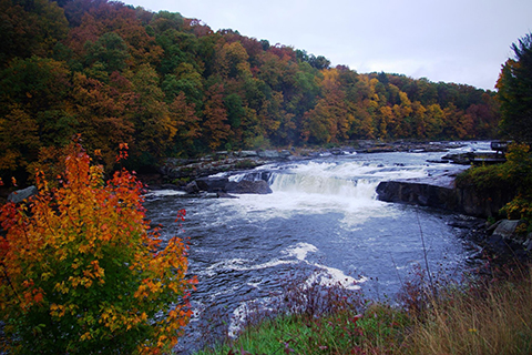
Ohiopyle Falls is a scenic, powerful waterfall on the Youghiogheny River. The falls show evidence of how they were formed. Upstream, the Youghiogheny River flows on a thick layer of horizontal, erosion-resistant Pottsville sandstone.
Downstream, the sandstone layer has been removed by erosion, causing the river to flow at a lower level. The erosion of the sandstone can be seen at the falls.
How To Get There: Ohiopyle Falls has its own ADA parking and viewing area by the park office/visitor center.
Pole Steeple
Pole Steeple is a resistant pinnacle of rock that provides a spectacular view of the South Mountain section of the Ridge and Valley physiographic province. The spires are strongly resistant, light-gray quartzite of the Montalto Member of the Harpers Formation.
To the north, less resistant rocks around Laurel Lake are metarhyolite and dolomite. These two rock types were faulted upward against the quartzite, and because they erode more rapidly than the quartzite, they now occupy a lower topographic position.
Evidence for faulting can be seen in the slickenside surfaces along the base of Pole Steeple, where rock slid on rock and polished it to a smooth surface
How To Get There: It can be accessed by the 0.75-mile-long Pole Steeple Trail from the lake or from the Appalachian Trail.

Presque Isle, literally translated from French as “almost island,” is a superb geologic example of the interaction of waves and sediment.
The landform is a “spit” -- a narrow tongue of sand and gravel attached to land. The action of the longshore current to the northeast turns the spit landward making it a “recurved spit.”
Its existence can be traced to the Ice Age, when Lake Erie was a valley occupied by a glacier pushing southwest. About 23,000 years ago, vast amounts of rock, sand, and debris were dumped as ice melted and retreated to the north.
How To Get There: Presque Isle State Park and the Tom Ridge Environmental Center can be reached by PA 832 north. The park can also be reached by boat. The road system within the park forms a loop approximately 13 miles in length.
Grand View and Kitchen Creek Gorge
Grand View, located in Ricketts Glen State Park, has an elevation of 2,449 feet. It is the highest point on Red Rock Mountain and provides for glimpses of a spectacular scenic overlook. Tree growth has obscured much of the view, and better views are possible when leaves are off the trees.
The imposing wall of the Allegheny Front stretches from east to west, rising as much as 1,200 feet above the rolling hills below.
The rim of the Allegheny Front is capped by a thick sequence of sandstone layers in the Huntley Mountain Formation. The hills in the foreground are underlain by less resistant interbedded shales, siltstones, and sandstones of the Catskill Formation.
To the southeast in the distance appear the narrow, even-crested ridges of the Ridge and Valley. At peak glaciation about 20,000 years ago, glaciers extended from Canada to Pennsylvania and covered the entire area. However, Red Rock Mountain was high enough that it remained above the ice.
How To Get There: Take Grandview Trail located in the park.
Kitchen Creek Gorge, located in Ricketts Glen State Park, cuts across the Allegheny Front, as Kitchen Creek descends 1,000 feet in a little over two miles and over about 25 waterfalls.
The rim of the Allegheny Front is topped by a thick sequence of sandstone layers in the Huntley Mountain Formation. This unit overlies the less resistant interbedded shales, siltstones, and sandstones of the Catskill Formation.
How To Get There: Take Falls Trail.
Balanced Rock
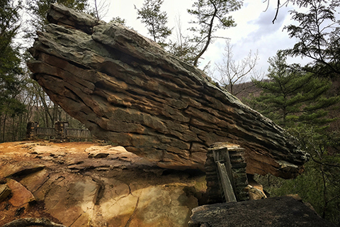
Balanced Rock can be found perched on the hillside along the west side of Trough Creek valley.
This huge block of Pocono Formation sandstone appears precariously balanced on the edge of the cliff ready to slide into the valley, but has actually been there for years.
How To Get There: Take Abbot Run Trail, beginning at the suspension bridge.
Canyon Vista
Canyon Vista in Worlds End State Park provides an excellent view to the northwest of the scenic Loyalsock gorge -- “one of the most wildly beautiful and remote sites in Pennsylvania.”
The view exemplifies the terrain of the Deep Valleys physiographic section of the Appalachian Plateaus province. The plateau is capped by resistant sandstone.
How To Get There: Canyon Vista is accessible via Mineral Spring and Cold Run roads.