Lehigh Gorge State Park
A deep, steep-walled gorge carved by a river, thick vegetation, rock outcroppings, and waterfalls characterize Lehigh Gorge State Park.
In Luzerne and Carbon counties in eastern Pennsylvania, the park follows the Lehigh River from the outlet of the U.S. Army Corps of Engineers Francis E. Walter Dam at the northern end, to the town of Jim Thorpe at the southern end of the park.
Whitewater boating and biking are popular activities.
The 6,107 acres of park land follow the Lehigh River from Francis E. Walter Dam in the north to Jim Thorpe in the south.
The Lehigh Gorge Trail follows more than 20 miles of the D&L Trail, the foundation of the 165-mile
Delaware and Lehigh National Heritage Corridor.
The abandoned railroad grade along the river provides opportunities for hiking, bicycling, sightseeing, and photography. The trail is closed to motor vehicles.
Parking areas are provided in White Haven, Rockport, and Glen Onoko. Very limited parking is available at Lehigh Tannery but boat launching is prohibited.
Seasons and Hours
The park is open every day of the year, sunrise to sunset. Day use areas close at dusk.
Contact the
Hickory Run State Park office for facility seasons and hours.
Directions
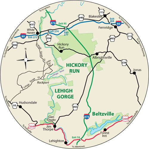
White Haven
White Haven is the northern access area and can be reached off exit 273 of I-80.
- For White Haven South Access Area, follow PA 940 west for a short distance and turn left at the park entrance.
South Access Area GPS Decimal Degrees: Lat. 41.055270 Long. -75.771581
- For White Haven North Access Area, follow PA 940 east, being sure to take a right turn at the stop sign in White Haven. Just after crossing the railroad tracks, turn left on Main Street. The parking area is at the intersection of Main and Susquehanna streets.
North Access Area GPS Decimal Degrees: Lat. 41.062944 Long. -75.773107
Lehigh Gorge State Park White Haven Area Map (PDF)
Rockport
Rockport is the central access area:
From the south:
- Follow US 209 south from Jim Thorpe to PA 93 north
- After six miles, turn right onto Brenckman Drive to the town of Weatherly
- Continue through Weatherly then turn right onto Lehigh Gorge Drive
- Turn right onto Rockport Road
From the north:
- Take Exit 273 off I-80.
- Follow PA 940 west for one mile then turn left onto Lehigh Gorge Drive.
- At the village of Rockport, turn left onto Rockport Road
Rockport GPS Decimal Degrees Lat. 41.9667 Long. -75.7551
Lehigh Gorge State Park Rockport Area Map (PDF)
Driving Directions from Rockport to Glen Onoko:
- Leave access area on Rockport Road
- 0.8 mi. At stop sign, turn left onto Lehigh Gorge Drive
- 3.6 mi. In Weatherly, cross open grate bridge, then turn left at T-intersection
- 2.5 mi. At stop sign, turn left onto PA 93 S
- 5.9 mi. At stop sign, turn left onto US 209 N
- 3.0 mi. At stop light, turn left onto PA 903 N
- 0.1 mi. At end of bridge, make first left onto Main Street
- 0.3 mi. Turn left at entrance to Lehigh Gorge State Park
- 1.6 mi. Enter parking area for Glen Onoko Access
Glen Onoko
Glen Onoko is the southern access area and may be reached by taking Exit 74 of the Northeast Extension of the Pennsylvania Turnpike:
- Follow US 209 south to Jim Thorpe
- Then take PA 903 north across the river
- At the stop sign, continue straight-leaving PA 903 which bears to the right
- Turn left at the entrance to the park
Glen Onoko GPS Decimal Degrees: Lat. 41.8835 Long. -75.75914
Lehigh Gorge State Park Glen Onoko Area Map (PDF)
Driving Directions from Glen Onoko to Rockport:
- Leave Glen Onoko Access
- 1.6 mi. Turn right at stop sign
- 0.4 mi. At stop sign, turn right onto PA 903 S
- 0.1 mi. At stop sign, turn right onto US 209 S
- 2.9 mi. Turn right onto PA 93 N
- 6 mi. In Hudsondale, turn right onto Brenckman Drive heading toward Weatherly
- 2.4 mi. At stop sign, turn right, cross bridge
- 0.1 mi. After crossing railroad tracks, turn right/li>
- 0.1 mi. At stop sign, go straight
- 0.3 mi. At T-intersection, turn left, then turn right at stop sign
- 3.2 mi. Turn right onto Rockport Road
- 0.8 mi. Follow Rockport Road to parking area
Top 10 Activities at Lehigh Gorge
- Take a group of friends for a bicycle ride (or a hike) along the river on the Lehigh Gorge Trail.
- Challenge yourself with a whitewater rafting trip.
- Experience the wonder of the Upper Grand Section of the Lehigh Canal by standing inside Lock 22 at Mud Run.
- Enjoy the view from the top of the Inclined Planes at Penn Haven.
- Snowmobile the 15-mile trail from Penn Haven to White Haven.
- Eat a picnic lunch to the beautiful sounds and sights of Buttermilk Falls.
- Explore the Audubon’s Lehigh Autotour.
- Photograph beautiful rhododendron along the Lehigh Gorge Trail in July.
- Find your own secret fishing hole in the nearly 30 miles of river or its numerous tributaries.
- Visit a neighbor --
Hickory Run State Park!
Water Features
Lehigh River
The river flows out of glacial bogs near Gouldsboro (2,100 above sea level) and journeys 103 miles through seven counties to the confluence with the Delaware in Easton.
The
Lehigh River (PDF) collects water from 1,227 miles of tributaries and 256 lakes in its watershed. It takes 24 hours for a drop of Lehigh River water to travel its 103-mile length.
Four tributaries (Sandy Run, Indian Run, Black Creek, and Nesquehoning Creek) in an 18-mile section of river are impacted by abandoned mine drainage.
The Lehigh was designated a Pennsylvania Scenic River April 5, 1982.
The 32-mile portion of the Lehigh River, including 13 tributary streams and related adjacent land areas, from the Francis E. Walter Dam in Luzerne County to Jim Thorpe in Carbon County is designated as a component of the Pennsylvania Scenic Rivers System under the Pennsylvania Scenic Rivers Act.
Waterfalls
Beautiful woodland waterfalls can be seen at several locations along the Lehigh Gorge:
- Cascade -- 0.25 mile South of Tannery
- Buttermilk Falls -- 0.25 mile north of Rockport Access
- Luke’s Falls -- 0.25 mile south of Rockport Access
Learn, Experience, Connect
A wide variety of environmental education and recreation programs are offered year round.
Through hands-on activities and guided walks, participants gain appreciation, understanding, and develop a sense of stewardship toward natural and cultural resources.
Contact Hickory Run State Park to inquire about school field learning experiences at 272-808-6192.
Access for People with Disabilities
This activity or structure is ADA accessible. If you need an accommodation to participate in park activities due to a disability, please contact the park you plan to visit.
In an Emergency
Call 911 and contact a park employee.
Directions to the nearest hospital are posted on bulletin boards.
Nearest Hospitals
White Haven and Rockport
Lehigh Valley Hospital-Hazleton
700 East Broad Street
Hazleton, PA 18201
570-501-4000
Glen Onoko
St. Luke’s Lehighton Campus
211 North 12th Street
Lehighton, PA 18235
610-377-1300