I’ve always been fascinated by mountain ranges. As a kid I devoured the family World Book Encyclopedia set learning about them. And I’m not unique…people worldwide flock to mountainscapes to stand or live in their magnificent shadows.
You may remember from Greek mythology that Mount Olympus was the home of the Greek gods….in fact, many cultures throughout history have glorified mountains with similar designations.
Mount Everest’s Tibetan name is Chomolungma, which means “goddess mother of the world.”
Ourea was the name the Greeks gave to the gods of the Olympic Range, and from that word we get the English word orogeny, which is our geologic term for mountain building.
Geologists theorize that an orogenic process called plate tectonics built our local Appalachian Mountains.
Simply put, the geologic record tells us that the earth’s crust is segmented into “plates” that drift around very slowly on the bed of molten lava below.
Some 280 million years ago, the African continent bumped the North American continent and created wrinkles in the earth’s crust at the collision site, the eastern United States.
Mountains Succumb to Weather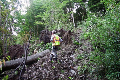
Since then, the once majestic Rocky Mountain-like Appalachians have been slowly succumbing to the effects of gravity.
When combined with water or wind, etc., that process is called erosion. Of course, erosion is greatly accelerated by flowing water and excessive rainfall.
The Grand Canyon of the Colorado was formed by the slow erosion (10 million years) by the river and its tributaries. Ten million years is, geologically speaking, the blink of an eye.
Rainfall typically results in relatively slow erosion as well, but downpours and deluges can speed the process.
Excessive rainfall that saturates deeply into the upper soil layer causes instability by reducing the friction between soil particles -- that’s how mud gets slippery.
When large sections of soil that are situated on a sloping hillside become saturated, they can be overcome by the force of gravity and break loose --the result is known as an avalanche, slump, or landslide.
Changing Climate Could Mean More Landslides
Since the turn of the 21st Century, rainfall in Pennsylvania has increased on the average of about 10 percent.
Also, the National Weather Service reports that, due to climate change, rainfall is occurring in brief downpours that can be as much as 70 percent wetter than downpours in previous decades.
The consequence of these downpours, of course, is the potential for more frequent landslides.
In recent years, the road system in the Loyalsock State Forest has been decimated by landslides and other erosive processes due to extraordinary rainfall events.
Where I work in the Tioga State Forest, recent landslides have closed roads and downed powerlines.
One recent downpour-induced landslide in the Pennsylvania Grand Canyon measures more than 600 ft long and 90 ft wide, moving thousands of tons of soil downslope and into Pine Creek in just seconds.
DCNR’s Bureau of Geological Survey notes that from February 15 to April 24, 2018, Allegheny and Westmoreland counties experienced a record number of landslides -- 171 and likely more that were not recorded -- while at the same time receiving a high amount of precipitation -- 12.55 inches. Southwestern Pennsylvania has by far the largest concentration of landslides in Pennsylvania.
DCNR’s Climate Change Plan Addresses Geologic Hazards
The department’s 2018 Climate Change Adaptation and Mitigation Plan (PDF) identifies geologic hazards as a vulnerability, and notes there will be increased demand for research and assistance.
It identifies these actions that are influencing the work of DCNR’s Bureau of Geological Survey:
- Develop research projects that look for relationships between the timing and intensity of weather events and sinkholes and landslides.
- Develop science-based key messages dealing with geologic hazards for multiple audiences.
- Create detailed information and maps on subsurface geology.
For more information about landslides, visit the DCNR website.