It’s no secret that Pennsylvania is home to some of the best hiking trails. Whether you’re striving to see that stunning overlook after an uphill climb, or pointing out the plants and wildlife on a leisurely stroll with your little ones, there are opportunities across the state to get out and hit that special trail.
But did you know that among these trails, there are some that you could spend days, weeks, or even months exploring? You can hike these paths straight through, break them up for a weekend adventure, or even explore sections one day at a time.
It just takes a bit of planning and a goal in mind!
Where to Go
Longer hiking trails sometimes cross through, or are solely in, our state parks and forests. Here are some longer trails and trail systems (at least 50 miles long) in Pennsylvania for you to explore! Many of them traverse through the remote and scenic Pennsylvania Wilds.
Chuck Keiper Trail
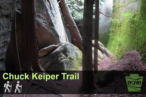
The 53-mile Chuck Keiper Trail covers some breathtaking views in Sproul State Forest. The Chuck Keiper Trail is a long-distance backpacking trail that covers scenic and secluded areas of the state forest. The trail system is divided into two loops -- the West Loop of 32.9 miles and the East Loop of 22.4 miles -- creating three- and two-day backpacking options or adventurous day hikes.
Named after a dedicated conservationist and wildlife law enforcement officer, this strenuous trail features many ascents and descents that reward hikers with scenic features including the waterfall at Yost Run, several miles of stream-side hiking along the bank of Eddy Lick Run, and remnants of logging history.
Donut Hole Trail and the Susquehannock Trail System
The 90-mile, point-to-point Donut Hole Trail is sure to challenge even the experienced hiker. The Donut Hole Trail heads north from Bucktail State Park through Kettle Creek State Park towards Tamarack. It then turns south in Sproul State Forest towards Hyner, passing through Hyner Run State Park before continuing south to Farrandsville. In cooperation with DCNR, sections of this trail are maintained, in part, by volunteers from the Keystone Trails Association.
Part of the Susquehannock Trail System (STS) runs in conjunction with the Donut Hole Trail, and the STS also has a connecting link to the Black Forest Trail. There are also two cross-over trails available to provide hikers with the option of a shorter loop hike.
The STS is an 85-mile loop hiking trail in Potter and Clinton counties. It’s is a series of 63 separate trails, most of which are old Civilian Conservation Corps fire trails. While the trail traverses through remote areas, it’s also close enough to civilization and modern amenities to be a great trail for a first-time backpacker.
The most secluded section of the STS is a 10-mile stretch through the state's largest wild area, the Hammersley Wild Area, offering hikers access into part of the most remote and pristine nature Pennsylvania has to offer.
There are no designated camping locations along the STS. If you are planning a camping trip, and you'll be camping at any one location for consecutive nights, you need to obtain a camping permit from the Susquehannock State Forest district office.
In cooperation with DCNR, sections of this trail are maintained, in part, by volunteers from the Susquehannock Trail Club. Learn even more from this hiker’s experiences.
Quehanna Trail
For a true backcountry wilderness experience, go for the 75-mile Quehanna Trail, which will take you on an adventure deep within Moshannon and Elk state forests. This strenuous loop trail near State College, Pa., passes through some of the most wild and beautiful country Pennsylvania has to offer.
The main orange blazed trail begins on the western end at Parker Dam State Park. From Parker Dam, the trail goes east into the Quehanna Wild Area toward Karthaus and Piper, then north toward Sinnemahoning, and finally west through the Marion Brooks Natural Area back to Parker Dam.
There are two blue blazed cross-connector trails and numerous blue-blazed side trails that add another 30 miles of trails so that the casual or avid hiker may spend a few hours or a few days enjoying the beauty of the Quehanna Wild Area.
In cooperation with DCNR, sections of this trail are maintained, in part, by volunteers from the Quehanna Area Trails Club. See DCNR’s eastern section map (PDF) and western section map (PDF).
Mid State Trail
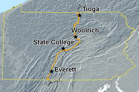
Image from the Mid State Trail Association
The Mid State Trail (MST) is known as the wildest footpath in Pennsylvania. More than 325 miles long, the trail stretches from the Maryland border in the Buchanan State Forest and traverses through the center of the state to end at the New York State line just north of Cowanesque Lake.
The MST is broken into four distinct regions. Hiking from south to north you will pass through the Everett region, State College region, Woolrich region, and the Tioga region. Each region has its own unique features, landscape, and geology.
The MST is not generally an easy trail, with some areas featuring sharp borders and edges, as well as some glacial mud. You can see spectacular vistas from mountain tops, and experience the remoteness of wild forests and streams on this trail.
The MST is mostly on public land, including state parks, forests, and game lands. It links or traverses many interesting places and sites, including scout camps, fire towers, and natural areas.
The level of use of this trail is relatively low, and it’s been said that you may meet more bears than people while hiking this trail. In cooperation with DCNR, sections of this trail are maintained, in part, by volunteers from the Mid State Trail Association.
Laurel Highlands Hiking Trail
The 70-mile Laurel Highlands Hiking Trail stretches along Laurel Mountain from the picturesque Youghiogheny River at Ohiopyle State Park to the Conemaugh Gorge near Johnstown. A stop at Ohiopyle State Park offers breathtaking views and waterfalls to explore.
Seasoned backpackers can challenge themselves on the steep, rugged areas of the trails. Casual hikers can enjoy areas that are reasonably level and pleasant for walking.
The trail is the main feature of Laurel Ridge State Park. It traverses state parks, state forests, state game lands, other public lands, and private lands. The Laurel Highlands Hiking Trail is a major segment of the Potomac Heritage National Scenic Trail.
The trail has a diversity of wildlife. From spring to fall you can find the occasional red back or spotted salamander finding the cool undersides of rocks and leaf litter to their liking. The box turtle, easily camouflaged with its yellow mottled shell, hides and looks for food on the forest floor during the summer months.
For those looking to trek the whole trail, overnight shelters can be reserved in advance. There are eight overnight shelter areas, one area every six to 12 miles along the trail. Each area contains five Adirondack shelters with fireplaces, two vault toilets, and space for 30 tents.
Crossing State Lines -- National Scenic Trails
National Scenic Trails are designated by Congress as protected trails of particular natural beauty and are managed by the National Park Service.
Pennsylvania features portions of three National Scenic Trails that travel through state forests and state parks, and continue to the surrounding states.
The National Scenic Trail system provides options for short hikes, long hikes, or a backpacking adventure through several states!
The National Scenic Trails in Pennsylvania are:
The Appalachian Trail
Easily one of the most famous trails ever established, the Appalachian Trail (AT) covers 230 miles in Pennsylvania. You can thru-hike the AT, or enjoy it in sections.
From the south, trail enters Pennsylvania near Pen Mar in Franklin County, proceeds generally northward for about 85 miles, crosses the Susquehanna River north of Harrisburg, then heads east toward New Jersey, leaving Pennsylvania near Delaware Water Gap.
The trail is marked with white blazes. Portions of the trail can be found in Caledonia, Pine Grove Furnace, Swatara state parks, as well as Michaux and Weiser state forests.
The AT is a 2,180-mile long public footpath that traverses the scenic, wooded, pastoral, wild, and culturally resonant lands of the Appalachian Mountains. Conceived in 1921, built by private citizens, and completed in 1937, today, the trail is managed by the National Park Service, U.S. Forest Service, Appalachian Trail Conservancy, numerous state agencies, and thousands of volunteers.
North Country Trail
Pennsylvania is home to about 260 miles of the North Country Trail (NCT). The initial 95 miles of the NTC in Pennsylvania from the New York border meanders through the rolling hills and stream valleys of the Allegheny National Forest.
Marked with white paint blazes and routed wooden signs, this northwestern Pennsylvania trail is one of the more established along the route of the NCT.
There are more than 30 marked campsites along the trail in the national forest. Forest service campgrounds, with services, are also available nearby. The trail extends down to Western Pa. into Ohio.
Portions of the trail can be found in Cook Forest, Chapman, Moraine, McConnells Mill state parks; Jennings Environmental Education Center; and Clear Creek State Forest.
The North Country National Scenic Trail is the longest in the National Trails System, stretching 4,600 miles over seven states from the middle of North Dakota to the Vermont border of New York.
Potomac Heritage Trail
The Potomac Heritage National Scenic Trail is a 710-mile trail network that lies within a corridor rich in historic pathways and waterways. The evolving trail network celebrates the heritage of the Potomac and upper Ohio river basins and offers opportunities for hiking, bicycling, boating, horseback riding, and cross-country skiing.
The trail has easy to strenuous sections in western Pennsylvania. Portions of the trail can be found in Point, Laurel Ridge, Ohiopyle state parks, and Forbes State Forest.
The Laurel Highlands Hiking Trail is a segment of this trail, where there are overnight areas and shelters.
Tips and Tricks for Safe Longer Hikes
Longer hikes require some extra planning. Here are some things for you to consider before you hit the trail:
- Check the weather before you go. Don’t go hiking if severe thunderstorms or tornadoes are in the forecast.
- Bring a friend and/or leave an itinerary behind and check in with loved ones when possible.
- Carry the essentials that you’ll need for your trip – water and water treatment tools, first aid kit, food/snacks, map, sunblock, bug repellant, fire making tools, overnight gear (if necessary).
- Dress for the hike. Wear proper footwear, a hat to protect you from the sun, and long socks/sleeves to protect you from the elements.
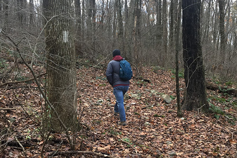
- Stay on the trail. You could become injured or lost when wandering off the trail, or you could disturb and destroy parts of the habitat you came to see.
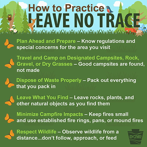
Leave No Trace
As you head out on your adventure, please remember to be considerate of your surroundings, wildlife, and others by following Leave No Trace ethics. By taking the time to practice responsible outdoor ethics, we can ensure that Pennsylvania state parks and forests can be enjoyed for generations to come.