History of Archbald State Park
Archbald Pothole was discovered in 1884 by coal miner Patrick Mahon while extending a mine shaft. Mr. Mahon fired a blast of explosives and water and stones came rushing out. The miners fled fearing that the mountain was falling on them. Edward Jones, the manager of the mining company, investigated and ordered the area cleared of debris. About 800 to 1,000 tons of small rounded stones were removed and Mr. Jones realized that the vertical tunnel was a large pothole.
About 1,000 feet north of Archbald Pothole, another pothole was found, but it was thought to be larger than the first pothole and was not excavated because of the excessive cost.
Archbald Pothole was briefly used as a ventilation shaft for the mine. A large fire kept burning in the bottom made the pothole function like a chimney, drawing air out of the mine. In 1887, Colonel Hackley, the landowner, built a fence and retaining wall around the hole. Edward Jones gave many tours of the pothole to local citizens and to noted geologists. The pothole became a popular tourist attraction. In 1914, the widow of Colonel Hackley donated a one-acre deed, which included the pothole, to the reformed Lackawanna Historical Society.
With the addition of 150 acres, Archbald Pothole became a Lackawanna County park in 1940. The county deeded the property to the Commonwealth of Pennsylvania 1961, and after improvements, Archbald Pothole State Park was dedicated in 1964.
Natural History
The Ice Ages
At least four ice advances, often called ice ages, have moved south into Pennsylvania. They are the:
Nebraskan
Kansan
Illinoian
Wisconsin
Most of the evidence of glaciers in Pennsylvania is from the most recent advance -- the Wisconsin Glacial Period. About 30,000 years ago, North America had a similar climate to modern time. Familiar animals lived here, but so did unique animals like:
For unknown reasons, the climate of the earth began to cool. Ice sheets in the arctic regions began slowly spreading in all directions. In the Northern Hemisphere, this glacier was called the Laurentide Continental Glacier and was several miles thick in the center while the edges were around 500 feet thick.
The glacier moved very slowly, sometimes only several feet a year. The edge of the glacier often advanced in the winter, only to partially melt back in the summer. Like a giant bulldozer, the glacier scraped the land, removing vegetation and soil, and flattening hills and ridges. On the top, edges, and underneath the glacier, ice melted and flowed in rivers carrying sand, pebbles, and boulders.
Near the glacier, the climate was very cold. Winter lasted for six months and the annual temperature was 20 to 25 F cooler than the current climate.
About 13,000 years ago, the Laurentide Continental Glacier was at its greatest size, and covered two-thirds of North America, including the northeast and northwest corners of Pennsylvania.
Again the climate changed, becoming warmer, and the giant blanket of ice quickly melted and retreated. Animals and plants slowly repopulated the warming lands, but many of the prehistoric animals became extinct.
Formation of the Pothole
A pothole usually is a hole that is worn into the bedrock of a stream at the base of waterfalls or in strong rapids. The moving water spins sand, gravel, and rock fragments in any small indentation in the bedrock. After enough time, the sand and stones carve out an elliptical hole. Potholes may also form under or near the edge of glaciers by the action of glacial meltwater.
Archbald Pothole was formed during the Wisconsin Glacial Period between 30,000 and 11,000 years ago.
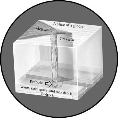
A meltwater stream flowing on top of the glacier probably broke through a crevasse (a crack in the glacier) and fell to the bedrock hundreds of feet below. There was enough force generated by the falling water to begin a whirling motion of rock fragments in a small depression.
As the rock fragments swirled and bumped each other, they carved the bedrock, making the depression deeper and larger. The rock fragments eventually were reduced to tiny particles, but new rock fragments continually tumbled into the hole, enabling the grinding process to continue.
As the glacier moved, so did the crevasse and the waterfall. Sand, gravel, and rounded stones filled in Archbald Pothole and the waterfall moved off to make new potholes.
At Archbald Pothole, the water first wore away the top layer of bedrock, which is sandstone. Next, the swirling water and rock carved through gray shale leaving a particularly smooth and polished surface that shows a typical, well-rounded, wavelike surface. This feature is especially noticeable in the lower half of the northern side of the pothole. The bottom layer of bedrock is black anthracite coal.
The southern and western sides of the pothole are nearly vertical, while the other two sides are deeply terraced. This is evidence that the waterfall that formed the pothole moved in a northeast and southwest direction. It is unknown whether the pothole formed during an advance or retreat of the glacier.
Preserved underground by nature for around 13,000 years, the pothole was uncovered during 1884 and has been exposed to weathering. The sides of the pothole are slowly eroding and are covered in ferns and lichens.
Please help preserve this signature of Pennsylvania's glacial history. If you observe someone vandalizing park property, please contact a park official.
For detailed information about Archbald Pothole, DCNR's Bureau of Topographic and Geologic Survey created the brochure, Trail of Geology 3 - Archbald Pothole State Park Guide (PDF).