Laurel Summit State Park
This scenic picnic area is operated by the DCNR’s Bureau of State Parks. The six-acre area offers picnic tables, a pavilion, water, and restroom.
The area is 2,739 feet above sea level and several degrees cooler than surrounding towns. This area also provides trailhead parking for Spruce Flats bog and Wolf Rocks Trail.
Laurel Summit is a carry in/carry out area. Please take all of your trash with you.
Seasons and Hours
The park is open every day of the year, sunrise to sunset. Day use areas close at dusk.
Contact the
Linn Run State Park office for facility seasons and hours.
Reservations
Make
online reservations or call toll-free 888-PA-PARKS (888-727-2757), from 7:00 A.M. to 5:00 P.M., Monday to Saturday.
Directions
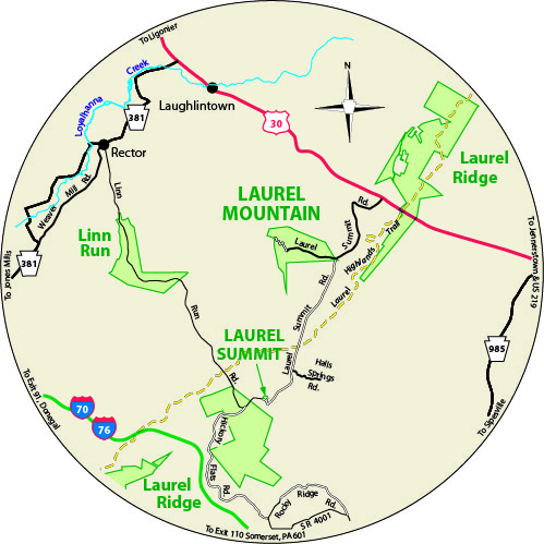
Laurel Summit State Park is in Westmoreland County, Pennsylvania, at the intersection of Linn Run Road and Laurel Summit Road.
GPS Decimal Degrees: Lat. 40.16082 Long. -79.1491
Access for People with Disabilities
This activity or structure is ADA accessible.
If you need an accommodation to participate in park activities due to a disability, please contact the park you plan to visit.
In an Emergency
Call 911 and contact an employee.
Directions to the nearest hospital are posted on bulletin boards.
Nearest Hospital
Excela Latrobe Hospital
121 West Second Avenue
Latrobe, PA 15650
724-537-1000